Benham Rise, also know as Benham Plateau, is a submerged landmass located approximately 250 kilometers east of the Philippine island of Luzon.
Geology
Benham Rise is a submerged extinct volcanic ridge located at 16 degrees 30 minutes N, 124 degrees 45 minutes E off the coast of Luzon, with the size of about 13,000,000 hectares. Its area is close to the Benham Seamount, located at 15 degrees 48 minutes N, 124 degrees 15 minutes E. The precise location is somewhere near the east of the Philippine Trench and near the south of the East Luzon Trench, both of which absorb the subducting force of the Philippine Sea Plate under the Philippine Mobile Belt, a collage of large blocks of that crust that amalgamated prior to the collision of the Philippine Sea Plate with the Eurasian Plate.
The origin of Benham Rise, along with a fellow landform, the Urdaneta Plateau (a remnant of mantle plume), is identified in one study as at least five sequences of propagating rifts, probably triggered by mantle flowing away from the mantle thermal anomaly. Its presence of the landform disrupts the continuity of this region (known as the Philippine-East Luzon Trench) by continuously colliding with the Sierra Madre mountain range of the eastern portion of the island of Luzon. Though it is generally thought that the Philippine Sea Plate is being subducted under the Philippine Mobile Belt, under the rules of tectonic subduction, there appears to be a resistance to this because of the presence of the landform, and instead, the plate is being displaced into the northern portion of Luzon to the west.
The geophysical features of Benham Rise may have been the result of an early Miocene collision event between the Benham Rise and the eastern margin of Luzon, which may have also allowed the inception of the NW striking strand of the Philippine fault. These forces may have impacted the shape of the island of Luzon because of the basaltic seafloor resisting the subduction that may have also cause the bending of the Philippine Fault. The active basins in Central Luzon, which trace an asymmetrical V shape, is the best place to observe the recent tectonic evolution of the fault system.
Benham Rise is connected to the mainland Luzon by the Palanan saddle and Bicol saddle. It also has two natural prolongations; the Narra spur and Molave spur. Being a seismically active region, Benham Rise is steadily "rising" approximately 2 centimeters every year. The shallowest part of Benham Rise is 35 to 50 meters below sea level.
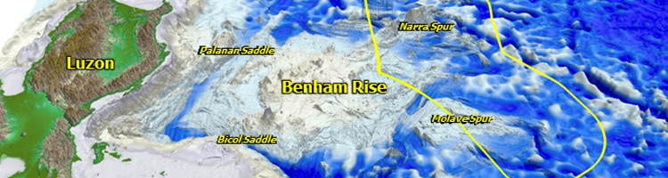
3D map of Luzon showing Benham Rise region and its prolongations, the Narra spur and Molave spur.
Map from NAMRIA.
Biodiversity
Benham Rise can be considered a biodiversity hotspot. The water above the area is pristine. Scientists and other personnel exploring the area said that they were able to see coral reefs by looking down the water while aboard the survey ship. Recent scientific exploration revealed that the area is rich in ocean lifeforms such as whaleshark, white-tip shark, yellow-finned tuna, puffer fish, grouper, surgeon fish, and has 120% coral reef cover - the healthiest in the Philippines. The excess 20% is due to the layers of coral reefs above another layer. Benham Rise is also the spawning ground for yellow-finned tuna.
Resources
Benham Rise is believed to be rich in oil and gas deposits that can supply the need of the Philippines. At present, the majority of fossil fuels consumed by the Philippines is imported from the Middle East. The area is also rich in manganese nodules that can be used in developing local steel industry. Fish catch from the area is also profitable. The Philippines' Bureau of Fisheries and Aquatic Resources said the area could yield an estimated 70 metric tons of fish catch per fishing operation. Benham Rise is also a good diving spot that can line up with other famous diving spots in the world.
Philippine Extended Continental Shelf Claim
Despite its proximity to the archipelago, the plateau was previously not included in the territory of the Philippines. On 8 April 2009, the Republic of the Philippines lodged a partial territorial waters claim with the United Nations Commission on the Limits of the Continental Shelf in relation to the continental shelf in the region of Benham Rise. It was submitted as part of petition expanding the archipelago's baselines and exclusive economic zone through a law that also included other claims involving disputed territories of the Kalayaan Islands (Spratly Islands) and Scarborough Shoal. The submerged landform is not disputed in nature. The Philippines' claim to the Benham Rise was officially approved by the United Nations on April 28, 2012. It is the first such claim won by the Philippines under the United Nations Convention on the Law of the Sea (UNCLOS). The approval of the claim gives the Philippines an additional of 13,000,000 hectares extended continental shelf.
The claim is part of the Philippine Extended Continental Shelf Delimitation Project which is geared towards meeting the United Nations' Commission on the Limits of the Continental Shelf (UNCLCS) guidelines for delineating the outer limits of the Philippines continental shelf. It will use a data set that will combine historical bathymetric, geological and geophysical data with similar data collected specifically for the Philippines' Extended Continental Shelf Project. These data and information will be the country's bases to claim maritime jurisdiction over seabed areas and its resources beyond 200 nautical miles from the baselines from which the breadth of the territorial sea is measured.
Recent Developments
On March 09, 2017, the Philippines' defense secretary Delfin Lorenzana said that satellite photos given by an undisclosed country indicate that a Chinese survey ship is in the area. The said ship is plying the waters of the eastern part of the Philippines from Luzon to Surigao. The intention of the said ship is unknown but may be looking for a place for Chinese submarines. Chinese foreign ministry spokesperson Geng Shuang clarified that the said ship is only exercising the principle of freedom of navigation and the right of innocent passage. The Philippines' defense secretary doubts Geng's statements, stating that the waters of Benham Rise region are not a traditional sea lane.
As a response to this incursion, the Philippines sent its navy and coast guard ships together with BFAR vessels to patrol the area. There is also an order from Philippine President Rodrigo Duterte to build structures above Benham Rise that signifies it is a part of the Philippine territory. A Filipino lawmaker also filed a bill to rename the area as "Philippine Rise" to assert the country's sovereign rights, while President Duterte himself wants to change the name to "Philippine Ridge".
Text content copied from:
Philippines' National Mapping and Resource Information Authority article Philippine ECS Delimitation Project
http://www.namria.gov.ph/projects.aspx
Wikipedia article Benham Plateau
https://en.wikipedia.org/wiki/Benham_Plateau
Some changes were made.
See those pages' history for attribution.
Last update: April 10, 2017
Text content made available for this website through http://creativecommons.org/licenses/by-sa/3.0/
Additional Readings:
http://www.denr.gov.ph/news-and-features/features/865-benham-rise-how-the-shelf-was-won.html
http://www.philstar.com/headlines/2014/06/02/1330219/filipinos-chart-new-territory-collect-data-benham-rise
http://news.abs-cbn.com/news/03/09/17/chinese-survey-ship-spotted-in-benham-rise-says-defense-chief
http://news.abs-cbn.com/news/03/14/17/ph-rebuffs-china-benham-rise-is-ours
Next article - - - Koppen Climate Classification
